
Geotagging of Houses in Delhi: Opposition and Legal Concerns
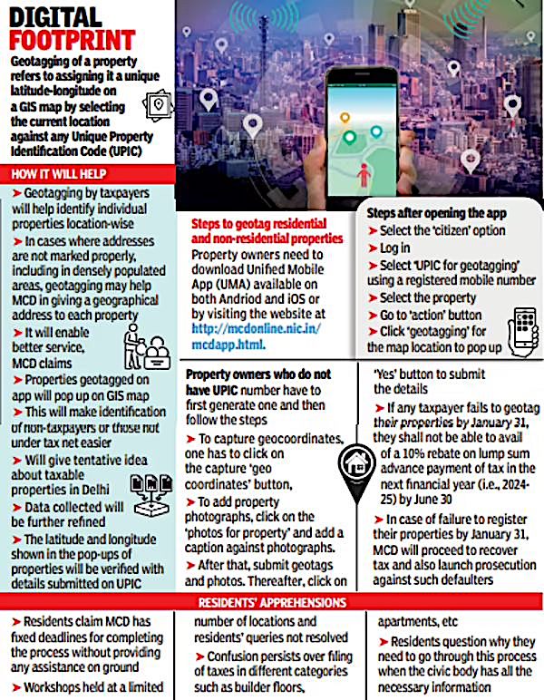
The Municipal Corporation of Delhi (MCD) has made geotagging of houses mandatory, which has raised concerns among citizens and experts. Geotagging involves assigning geographical coordinates to a property, which can be used to identify its location.
Opposition to Geotagging
The decision to make geotagging mandatory has been opposed by various groups, including citizens, activists, and privacy advocates. They argue that geotagging without informed consent is a violation of the right to privacy. The opposition is based on concerns that geotagging could lead to misuse of personal data and compromise the security of citizens.
Legal Concerns and Challenges
Those opposing geotagging argue that it can be stopped or challenged under various laws and sections. Some of the key legal concerns include:
- The Right to Privacy: The Supreme Court of India has recognized the right to privacy as a fundamental right under the Constitution of India (Article 21). Geotagging without informed consent may be considered a violation of this right.
- The Information Technology Act, 2000: Section 43A of the IT Act requires companies to implement reasonable security practices to protect sensitive personal data. Geotagging without proper safeguards may be considered a breach of this provision.
- The Personal Data Protection Bill, 2019: Although the Bill is yet to be passed, it proposes to regulate the processing of personal data, including geolocation data. Geotagging without compliance with this Bill may be considered illegal.
Informed Consent
Informed consent is a crucial aspect of data collection, including geotagging. Citizens have raised concerns that they were not provided with adequate information about the purpose and scope of geotagging. The MCD has been criticized for not obtaining explicit consent from citizens before collecting their geolocation data.
Flaws in Geotagging
Several flaws have been identified in the geotagging process:
- Inaccuracy: Geotagging may not always be accurate, which can lead to incorrect identification of properties.
- Misuse of Data: Geolocation data can be misused by unauthorized parties, compromising citizen security.
- Lack of Transparency: The MCD has been criticized for lacking transparency in its geotagging process, including the purpose and scope of data collection.
The opposition to geotagging can be addressed through legal challenges under various laws, including the Constitution of India (Article 21), the Information Technology Act, 2000 (Section 43A), and the proposed Personal Data Protection Bill, of 2019. Citizens can also seek relief through court interventions and RTI applications
Ref:
- Delhi govt’s geotagging exercise raises privacy concerns. [ https://www.thehindu.com/news/cities/Delhi/delhi-govts-geotagging-exercise-raises-privacy-concerns/article33511114.ece ]
- Justice K.S. Puttaswamy (Retd.) vs Union Of India on 24 August 2017. [https://indiankanoon.org/doc/143107824/ ]
- MCD’s geotagging drive: Citizens raise concerns over privacy. [The Times of India]
- Geotagging: A boon or a bane? [The Financial Express]
- How geotagging can compromise your security. [The Economic Times]
- Delhi: MCD’s geotagging exercise raises questions over data security. [Hindustan Times]

What is Geo-Spatial Data?
- Geospatial data is data about objects, events, or phenomena that have a location on the surface of the earth.
- The location may be static in the short-term, like the location of a road, an earthquake event, malnutrition among children, or dynamic like a moving vehicle or pedestrian, the spread of an infectious disease.
- Geospatial data combines location information, attribute information (the characteristics of the object, event, or phenomena concerned), and often also temporal information or the time at which the location and attributes exist.
- Geo-spatial data usually involves information of public interest such as roads, localities, rail lines, water bodies, and public amenities.
Applications of Geospatial Technology
Geospatial technology can be used to create intelligent maps and models which help to collect geographically referenced data.
Intelligent maps and models can be created using geospatial technology. It can be used to reveal spatial patterns hidden in large amounts of data that are complex to access collectively through mapping.
The scope of geospatial data use is vast: it embraces every sphere or industry where geographical position matters. The list includes geography proper, ecology, tourism, marine sciences, agriculture, forestry, marketing and advertising, military forces, navy, aircraft, law enforcement, logistics and transportation, astronomy, demography, healthcare, meteorology, and many others.
Here are some typical examples of how geospatial technology is applied:
- Tracking goods and ensuring their quality.
- Identifying location and time of arrival, route making, and navigation.
- Referring weather forecasts to particular territories.
- Detecting forest fires and deforestation & preventing large-scale wildfires ( example: satellite monitoring of forest fires and deforestation). Assessing vegetation state on a selected terrain.
- Healthcare. Monitoring areas of epidemic outbreaks.
- Tracing species populations in certain areas, preventing and addressing calamities.
- Marketing and advertising.Targeting ads to relevant regions.
- Real estate.Visualizing and analyzing real estate objects remotely.
- Managing risks in questioned areas (e.g., via historical georeferenced data analysis).
| Use of Geo-enabled Technology amid Covid-19The recent Covid-19 pandemic management is a remarkable example where geo-enabled technology was used to develop a health service app, which helped in identifying containment zones, aided in monitoring citizen movement, administrating vaccines and ensuring social distancing. Other geo-enabled technologies helped in managing activities like sanitizing hotspots, establishing telemedicine facilities for remote health care and diagnosis, and analysing infrastructure availability to address the health crisis. |
The National Geospatial Policy 2022 was notified by the Science & Technology Ministry.
Geospatial Technology
- Geospatial Technology includes Geographic Information System (GIS), Remote Sensing (RS), and Global Positioning System (GPS).
- Geospatial technology enables us to acquire data that is referenced to the earth and use it for analysis, modeling, simulations, and visualization. Geospatial technology allows us to make informed decisions based on the importance and priority of resources most of which are limited in nature.

National Geospatial Policy, 2022
About:
Aim and Objectives:
- Working towards creating an enabling infrastructure for the sector.
- Bring out a high-resolution topographical map covering every inch of the country by 2030
- Bring out fashion digital twins of India’s major cities and towns by 2035.’
Mandate:
Under the policy, the central government will constitute a Geospatial Data Promotion and Development Committee (GDPDC) at the national level. GDPDC will be the apex body for formulating and implementing appropriate guidelines, strategies and programmes for the promotion of activities related to the geospatial sector.
GDPDC
The GDPDC is a 17-member body to be headed by a person of repute from industry, government or academia, that will drive the overall development of the geospatial ecosystem. It will replace and subsume the functions and powers of National Spatial Data Committee (NSDC) constituted in 2006 and Geospatial Data Promotion and Development Committee constituted in 2021.
The focus of the Policy is to make geospatial technology and data as agents of transformation for achieving Sustainable Development Goals (SDGs).
It will also try to bring efficiency in all sectors of the economy and instill accountability and transparency at all levels of governance.
Significance:
The national geospatial policy 2022, comes at a time when India’s geospatial economy is expected to cross Rs 63,000 crore by 2025 at a growth rate of 12.8%. The sector is expected to provide employment to more than 10 lakh people mainly through geospatial start-ups.
Future of Geospatial technologies
Geospatial technologies enhance the performance of artificial intelligence and smart machinery in multiple spheresand agriculture in particular. Remotely controlled equipment completes numerous tasks via GPS and digital dashboards. Robots and smart machinery in the fields seem futuristic no longer, and it is not the limit.
Expansion and new application solutions are expected in biosecurity, education, construction, engineering, ecology, food supplies, precision agriculture, financial market, statistics, transportation,to mention a few.
Basically, geospatial data enhances performance in each sphere, outlining specific needs or issues in selected regions. Example: Employment of GPS in the automobile and aircraft industries enables frequent use of driverless vehicles and UAVs as a matter of fact.
New achievements in this branch mean the corresponding upgrade of related industries. So, the improvement process will be ensuring even greater precision, credibility, performance, quality, and security.
Democratization of Indian geospatial ecosystem will spur domestic innovation and enable Indian companies to compete in the global mapping ecosystem by leveraging modern geospatial technologies and realizing the dream of “Atmanirbhar Bharat” or “Self-sufficient India” fully.
DEREGULATION OF THE GEOSPATIAL SECTOR
What was the previous policy on Geospatial Data?
· There were strict restrictions on the collection, storage, use, sale, and dissemination of Geo-Spatial Data and mapping earlier.
- · The policy had not been renewed in decades and had been driven by internal as well as external security concerns.
- · The sector was dominated by the Indian government as well as government-run agencies such as the Survey of India and private companies need to navigate a system of permissions from different departments of the government (depending on the kind of data to be created) as well as the defence and Home Ministries, to be able to collect, create or disseminate geo- spatial data.
· GIS mapping was also rudimentary, with the government investing heavily in it after the Kargil war highlighted the dependence on foreign data and the need for indigenous sources of data.
· This system of acquiring licenses or permission, and the red tape involved, can take months, delaying projects, especially those that are in mission mode – for both Indian companies as well as government agencies.
The government has deregulated Geo-Spatial Data
· The deregulation eliminates the requirement of permissions as well as scrutiny, even for security concerns.
· Indian companies now can self-attest, conforming to government guidelines without actually having to be monitored by a government agency- these guidelines therefore place a great deal of trust in Indian entities.
· There is also a huge lack of data in the country which impedes planning for infrastructure, development and businesses which are data-based. The mapping of the entire country, that too with high accuracy, by the Indian government alone could take decades.
· The government, therefore, felt an urgent need to incentivize the geospatial sector for Indian companies and increased investment from private players in the sector.
· There has also been a global push for open access to geospatial as it affects the lives of ordinary citizens, and the new guidelines has ensured such open access, with the exception of sensitive defence or security-related data.
Ref: https://www.iasgyan.in/daily-current-affairs/national-geospatial-policy-2022
Understanding the Geotagging Policy in India
The geotagging policy in India is governed by various laws and guidelines, including the National Map Policy, 2005, and the Remote Sensing Data Policy, 2011. These policies regulate the creation, dissemination, and use of geospatial data in India.
Legal Framework for Expressing Dissent
Residents in India can express their dissent against the geotagging policy legally through various channels. One way is to file a petition under the Right to Information (RTI) Act, 2005, to seek information about the policy and its implementation. They can also approach the courts, such as the High Courts or the Supreme Court, to challenge the policy on grounds of constitutionality or other legal grounds.
Public Participation and Consultation
The government can be encouraged to revisit or amend the geotagging policy through public participation and consultation. The government often invites comments and feedback on draft policies and bills. Residents can participate in these consultations to express their views and concerns.
Filing a Public Interest Litigation (PIL)
Residents can file a Public Interest Litigation (PIL) in the High Courts or the Supreme Court, arguing that the geotagging policy infringes on their fundamental rights or is otherwise not in the public interest. The PIL can be used as a tool to challenge the policy and seek judicial review.
Engaging with Elected Representatives
Another way to express dissent is by engaging with elected representatives, such as Members of Parliament or State Legislatures, and bringing their concerns to their attention. Elected representatives can be lobbied to raise the issue in the legislature and push for changes to the policy.
Using Social Media and Public Forums
While not a formal legal channel, social media, and public forums can be used to raise awareness about the issue and mobilize public opinion against the geotagging policy. This can create pressure on the government to reconsider or amend the policy.
Residents in India can express their dissent against the geotagging policy legally by filing RTI petitions, approaching the courts through PILs, engaging with elected representatives, and participating in public consultations.
Ref:
- Legal Challenges to Mapping in India #1 – Laws, Policies, and Cases. [ https://cis-india.org/openness/legal-challenges-to-mapping-in-india-1-laws-policies-cases ]
- The Right to Information Act, 2005.
- Draft National Geospatial Policy, 2021.[https://www.medianama.com/2021/05/223-summary-draft-national-geospatial-data-policy-2021/]
- Geospatial policy notified, hi-resolution Indian map by 2030 [https://timesofindia.indiatimes.com/india/geospatial-policy-notified-hi-resolution-indian-map-by-2030/articleshow/96606447.cms]
WEF– Bill Gates Agenda Contributor:

The Bill & Melinda Gates Foundation has been working in India for over two decades, partnering with the government, researchers, and entrepreneurs to improve health and development. The foundation is also involved in initiatives related to digital public infrastructure (DPI) and AI
The Food Innovation Hubs Global Initiative has been catalyzed by the World Economic Forum with a diverse group of organizations including support from Government of Netherlands, Mohammed Bin Rashid Al Maktoum Global Initiatives, United Arab Emirates and The Bill and Melinda Gates Foundation.
E-money (cashless), flood-proof rice(GMO), Health (Vaccine): Melinda, Bill Gates on innovation for India
Bill Gates, 27 Jan 2016: ..it comes from the digital realm, which allows us to help track things. Eventually, everyone will have electronic medical records, and you’ll just type in any concerns you have and be connected to the right resources. Also, in medicine, these new vaccines…
Innovation largely comes from the digital realm, which helps us track things. Eventually, everyone will have electronic medical records, allowing concerns to be recorded and connected to the right resources. In medicine, new vaccines invented just last decade show promise—for example, we still don’t have vaccines for HIV, but we’re optimistic one will come in the next decade, along with vaccines for malaria and tuberculosis. Biological sciences are advancing as quickly as digital sciences, enabling us to set ambitious global goals for 2030. Without innovation, those goals would be unachievable.
More countries are contributing to innovation now—it’s not just the U.S., but also China and India. India, for example, is building up its pharmaceutical sector, and China is a key partner, with companies like Serum Institute and others at the cutting edge, understanding how to produce high volume at low cost. Innovation also speeds up timelines favorably.
The digital revolution improves governance quality by allowing us to gather data on basic service delivery—like whether teachers show up—and identify who is performing best, helping spread best practices. Cell phones are now ubiquitous, even among community health workers. They receive optimized daily schedules on their phones, training materials, and sometimes villagers even listen to the training content on their devices. Digital technology is reaching remote places in incredible ways.
We also see technology transforming agriculture, such as flood-resistant rice that benefits many farmers in Uttar Pradesh. This rice can survive being underwater for two weeks, accommodating the increasing frequency of rains, which leads to much higher yields.
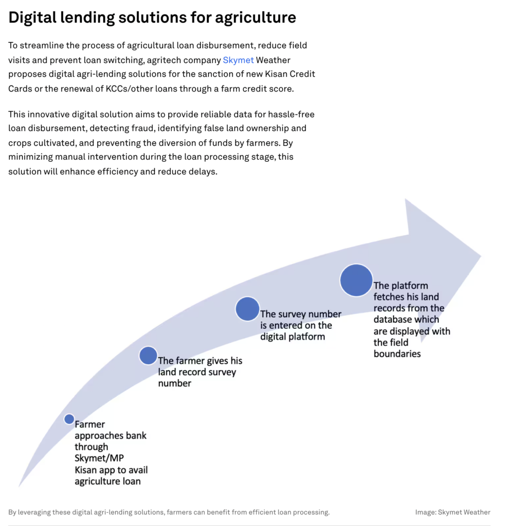
Another important innovation is digital money. The Central Bank’s creation of payment banks, which will begin operations soon, promises to revolutionize access to credit for farmers, reduce fees, and ensure government payments reach the intended recipients.
it begins with WEF
World Economic Forum and Geotagging:
Several areas within the WEF’s work indirectly involve or benefit from geotagging and geospatial data:
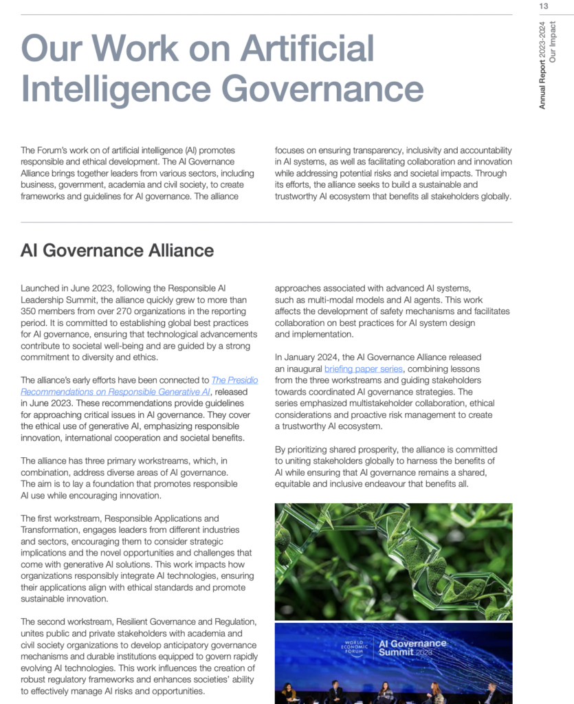
Earth observation data to tackle development challenges: Reflections from the WEF Annual Meeting in Davos
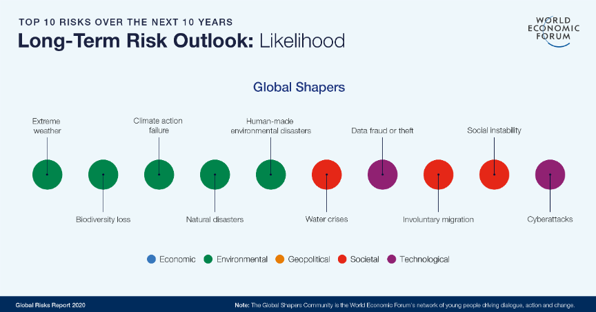
Planned to Control the Word by WEF -2025
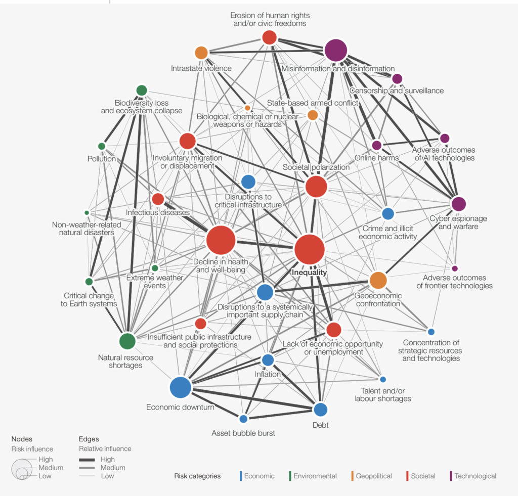
WEF: Applications of Geospatial Data
The WEF emphasizes that Earth Observation (EO) brings together vital data about our planet’s systems, helping organizations anticipate risks and act faster. This includes data from satellites, mobile phones, and other technologies, providing a clearer picture of the Earth’s physical, chemical, and biological systems . The WEF’s recent white paper, “The Executive’s Playbook on Earth Observation,” explores how EO can support smarter decision-making in business and policy, including early warning systems, boosting business efficiency, and strengthening accountability
The WEF highlights several key areas where geospatial data can be applied:
The Role of AI and Embeddings
- Understanding and Preventing Risks: EO can be used to monitor and analyze data to counter extreme weather events, predict natural hazards, and provide early warning systems.
- Improving Accountability: EO can improve transparency and information sharing, enhancing accountability across various sectors .
- Driving Efficiency: EO can help improve decision-making in agriculture, construction, and transport and logistics.
- Consumer Experience: Providing individual users value through information such as air quality or weather forecasts.
- Environmental Impact Monitoring: Providing a trusted, third-party source to measure environmental impacts and help verify certain environmental commitments and mandates.
- Precision Agriculture and Aquaculture: Enhancing regenerative practices, reducing input costs, and monitoring in-season performance and yield.
- Route Optimization: Optimizing transport routes in concert with GPS data by detecting potential environmental disruptions and offering alternatives based on environmental impact.
- Site Selection: Identifying operational sites for large-scale infrastructure with the best yield, efficiency, and relative environmental impact.
- Supply Chain Monitoring: Detecting changes to physical goods supply chains and their impacts on international commerce and ecological indicators.
- Vulnerability Analysis: Characterizing and assessing the risks posed by climate and nature changes and other hazards that may materially impact people, infrastructure, and operations.
Economic and Environmental Benefits
The WEF recognizes the role of AI, particularly in the form of “embeddings,” in revolutionizing Earth observation. AI-based embeddings translate raw data into meaningful insights, uncovering hidden patterns within Earth’s surface data. This technology can be used to create new maps and analyze vast archives of existing Earth observation data, such as identifying forests, river flows, and cities. The WEF highlights that AI for Earth offers unique benefits for the wider field of AI governance, particularly due to the availability of open data with open licenses.
Challenges and Strategies
The WEF, in collaboration with Deloitte, found that the potential value added from Earth data is estimated to reach US$703 billion in 2030, with a cumulative US$3.8 trillion contribution to global gross domestic product between 2023 and 2030. Earth observation can also inform interventions that stand to reduce greenhouse gas emissions by more than 2 billion gigatons of carbon dioxide equivalent annually. The WEF emphasizes that by 2030, over US$550 billion in economic value associated with downstream uses of Earth observation could be tied to applications with sustainability benefits.
The WEF acknowledges challenges in the adoption and application of geospatial data, including the need for expertise in AI, geospatial analysis, and sustainability. The WEF suggests strategies to overcome these challenges:
The WEF highlights various initiatives and examples related to geospatial data:
Examples and Initiatives
- Expanding the reach of Earth data and insights to enable increased global adoption.
- Cocreating solutions with end users to maximize Earth observation’s positive societal impact.
- Positioning Earth observation as a principal data source for environmental disclosures to help meet regulatory requirements.
- Focusing on the government’s influence as a buyer to invest in scalable commercial services.
The WEF emphasizes that the integration of space and terrestrial-based data, analyzed using AI and machine learning, can create transformative potential for businesses, leading to more informed decisions and new opportunities for efficiency and sustainability.
- Orbital Insight: A geospatial big data company that processes satellite and UAV imagery to study social and economic trends.
- Digital Earth Africa: An initiative working to translate freely available Earth observation data into useful information and services to address challenges in food, water, and economic security for the continent.
- Collaboration with MIT Media Lab: The WEF has collaborated with the MIT Media Lab on a white paper exploring key trends in EO.
- Partnerships with Companies: The WEF has partnered with companies like McKinsey & Company to explore how space technology is revolutionizing supply chains and mobility.
- UP42: A subsidiary of Airbus, which expands the market beyond the traditional customer base and makes it easier to find, buy and use geospatial products from existing providers.
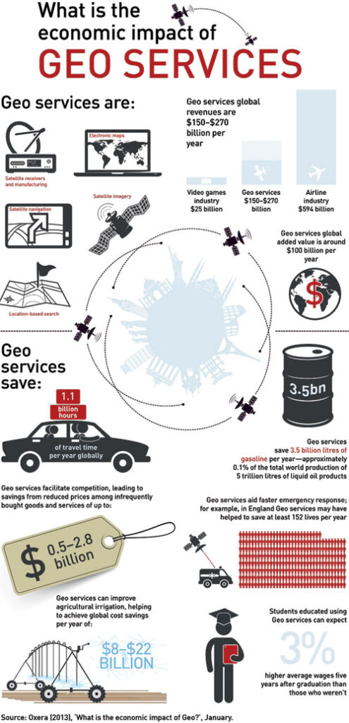
Geospatial technology, information, and services are addressing some of the major priorities of our nations, adding value to productivity, reducing costs and enabling GDP growth in the process
Ref:
- How AI is revolutionizing Earth observation. [https://www.weforum.org/stories/2024/10/ai-embeddings-earth-observation/]
- Earth Observation can help tackle global challenges from space – here’s how. [ https://www.weforum.org/stories/2025/03/earth-observation-space-tech/ ]
- Orbital Insight. [ https://www.weforum.org/organizations/orbital-insight/ ]
- Earth observation is a valuable tool in today’s data-driven world. [ https://www2.deloitte.com/us/en/insights/industry/public-sector/earth-observation-sustainable-economic-growth.html]
- Charting the Future of Earth Observation: Technology Innovation for Climate Intelligence. [ https://www.weforum.org/publications/charting-the-future-of-earth-observation/ ]
- Space technology is revolutionizing supply chains and mobility. This is how it will impact companies and consumers. [ https://www.weforum.org/stories/2025/05/how-space-technology-is-revolutionizing-supply-chains-and-mobility/ ]
- A new paradigm for business of data. [ https://up42.com/blog/a-new-paradigm-for-business-of-data-up42-featured-in-world-economic-forum ]
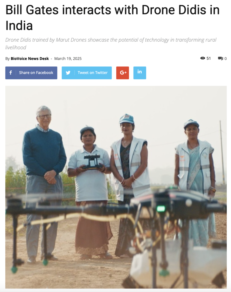
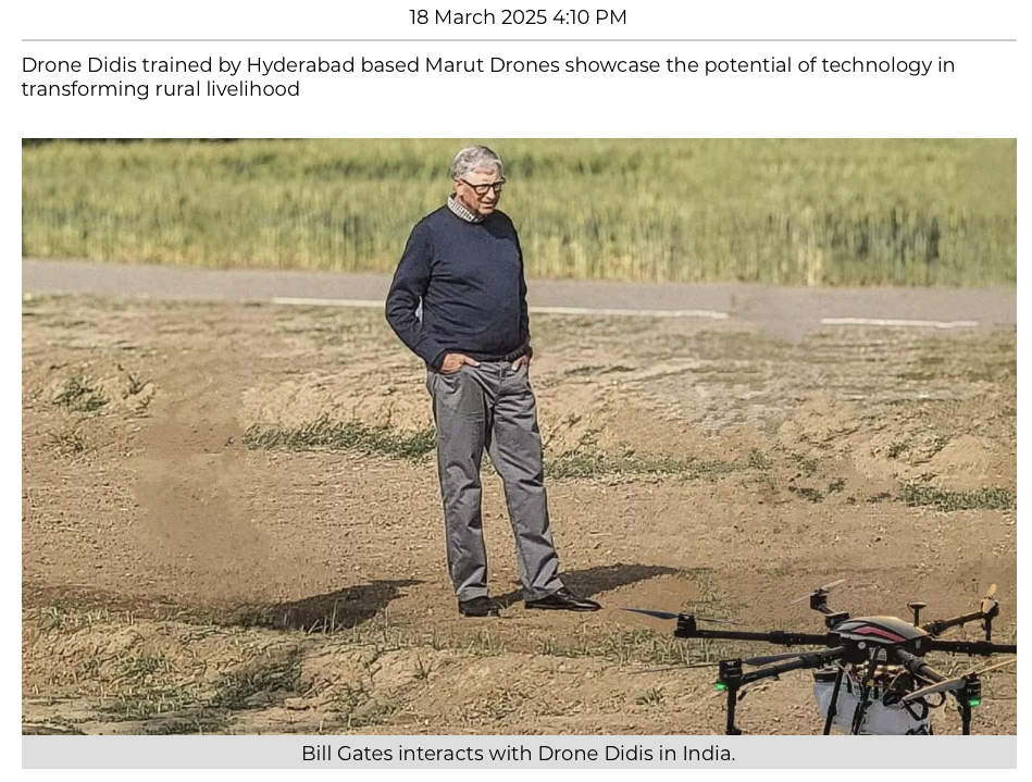
India’s Drone Shakti Scheme to Empower Startups for a Drone Revolution
December 05, 2024
The Drone Shakti Scheme is a flagship initiative by the Government of India designed to propel the growth of the drone industry and foster innovation among startups. Announced during the Union Budget 2022-23, the scheme aligns with the government’s broader vision of a digital and self-reliant India (Aatmanirbhar Bharat). It aims to boost the adoption of drone technology across various industries, create employment opportunities, and make India a global leader in drone manufacturing and services.
Key Objectives of the Drone Shakti Scheme
The Drone Shakti Scheme focuses on several objectives critical to the development of the drone ecosystem in India:
1. Encouraging Startups: The scheme prioritizes supporting startups in drone manufacturing, technology, and service innovation. By offering financial and technical assistance, the initiative seeks to unlock the entrepreneurial potential in this burgeoning sector.
2. Skill Development: To ensure a steady supply of skilled personnel, Drone Shakti emphasizes training and certifying drone pilots and technicians through partnerships with educational institutions and private enterprises.
3. Sectoral Integration: The scheme promotes the use of drones across sectors such as agriculture, logistics, infrastructure, surveillance, and disaster management. This integration aims to boost operational efficiency and reduce costs for businesses.
4. Promotion of Drone-As-A-Service (DrAAS): By encouraging the DrAAS model, the scheme enables companies to access drone services without owning expensive equipment, lowering the barrier to entry and broadening the technology’s reach.
Government Support and Incentives
The scheme offers multiple incentives for startups and enterprises to accelerate adoption and innovation:
• Financial Grants: Startups can avail of funding and subsidies to develop and commercialize drone technology and services.
• Ease of Regulations: The government has simplified drone policies, including reducing permissions under the Drone Rules, 2021, and introducing the Production-Linked Incentive (PLI) scheme for drone manufacturing.
• Infrastructure Development: The scheme supports building dedicated drone hubs and research facilities to foster collaboration and innovation.
Implications for Indian Industries
The Drone Shakti Scheme is set to revolutionize various sectors in India:
• Agriculture: Drones are being deployed for precision farming, pesticide spraying, and monitoring crop health, ensuring higher productivity and reduced resource wastage.
• Healthcare: Drones enable faster delivery of medical supplies, especially in remote areas, ensuring timely care during emergencies.
• Logistics and Transportation: Companies are leveraging drones for last-mile deliveries, reducing costs and improving efficiency.
• Infrastructure and Construction: Drones are transforming construction management with detailed site surveys, real-time data collection, and safety inspections.
• Disaster Management: Drones play a vital role in search and rescue operations, surveying disaster-hit areas, and delivering relief materials.
Employment Generation and Skill Development
The Drone Shakti Scheme is expected to create thousands of jobs, from drone manufacturing and programming to piloting and maintenance. The establishment of drone training institutes across India ensures a steady talent pipeline. Educational institutions are increasingly offering specialized courses and certifications to meet industry demands.
Aligning with Aatmanirbhar Bharat
Drone Shakti underscores India’s commitment to becoming self-reliant in cutting-edge technology. The government envisions reducing import dependency and strengthening indigenous capabilities in drone production and services.
Challenges and the Way Forward
While the Drone Shakti Scheme holds immense promise, challenges remain:
1. High Initial Costs: Despite subsidies, the initial investment in drones and related infrastructure can be high for startups.
2. Technological Gaps: Indian manufacturers need to keep pace with global technological advancements to remain competitive.
3. Privacy Concerns: The widespread use of drones raises concerns about data security and privacy, requiring robust regulatory frameworks.
To address these challenges, the government continues to refine policies, promote research and development, and foster public-private partnerships.
Ref: https://www.dronecraft.in/india-s-drone-shakti-scheme-to-empower-startups-for-a-drone-revolution


India Showcases SVAMITVA as Country Champion at the On-going World Bank Land Conference 2025
SVAMITVA scheme participation by India at the World Bank Land Conference 2025 aims to showcase the program’s achievements in rural empowerment, digital land governance and global collaborative efforts.
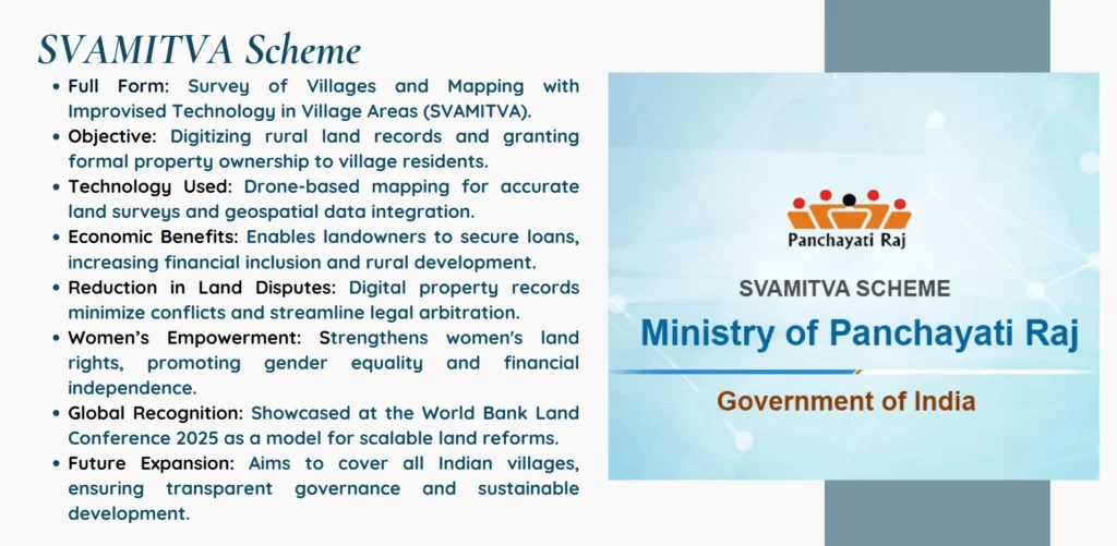
After its appearance at the World Bank Land Conference 2025 in Washington, D.C. the SVAMITVAScheme established itself as a world leader in digital land governance. The SVAMITVA serves as India’s national champion program for utilizing drone and geospatial technology to create digital rural land records while giving power to landowners and improving governance processes. The complete program enables rural landowners to secure legal title ownership thus foster economic development and reduce property conflicts alongside improved financial resource access. The conference activities demonstrate India’s commitment to worldwide land tenure reforms that combine open government strategies with modern technology solutions. SVAMITVA shows promise to transform worldwide land administration through its blend of adaptable implementation with its capability to duplicate successful land management models. India emerged as the conference leader through its dedicated use of technological solutions for rural development.

The SVAMITVA (Survey of Villages and Mapping with Improvised Technology in Village Areas) scheme will shape the ownership of properties and administrative frameworks in rural area. Initiated on, 24th of April 2020 by Honourable Prime Minister of India Narendra Modi to officially offer record of rights to the owners of the Household of the village and thus bringing financial stability and legal certainty to millions.
However, the claim of right to own land has been a burning issue in rural India. Lack of record in the system over land records ultimately results into legal and court cases, and difficulties in obtaining loans from the commercial banks. These challenges are due to other problems that SVAMITVA wants to solve by using contemporary technologies to demarcate the rural inhabited lands and issue.
Objectives and Key Features
- Property Documentation: The main objective of SVAMITVA is to provide property cards to owners of village households. This will go a long way in establishing order in land registry, cut down uneven disputes and enhance on transparency of property dealing.
- Technology-Driven Mapping: This involves use of drones and other technologically sophisticated ways of undertaking surveys as well as mapping the village land. This approach is scientific and fully excludes any possibilities of the parties being in dispute over the boundaries of properties.
- Empowering Villagers: SVAMITVA in transmitting villager property cards helps the villagers in getting legal documents of their property. It also serves to protect their proprietary interests as well as create a way through which they can access credit facilities and bail out among others.
- Boosting the Economy: Another advantage of clear titling in itself is that the property rights of the villagers make it easier for them to use their land as securities in borrowing, thus leading to development. It also encourages investment in rural areas, fostering overall development.
Implementation Strategy
The SVAMITVA scheme has been jointly launched with the Survey of India, State Revenue Department, Panchayati Raj Department and other related departments. The process involves the following steps:
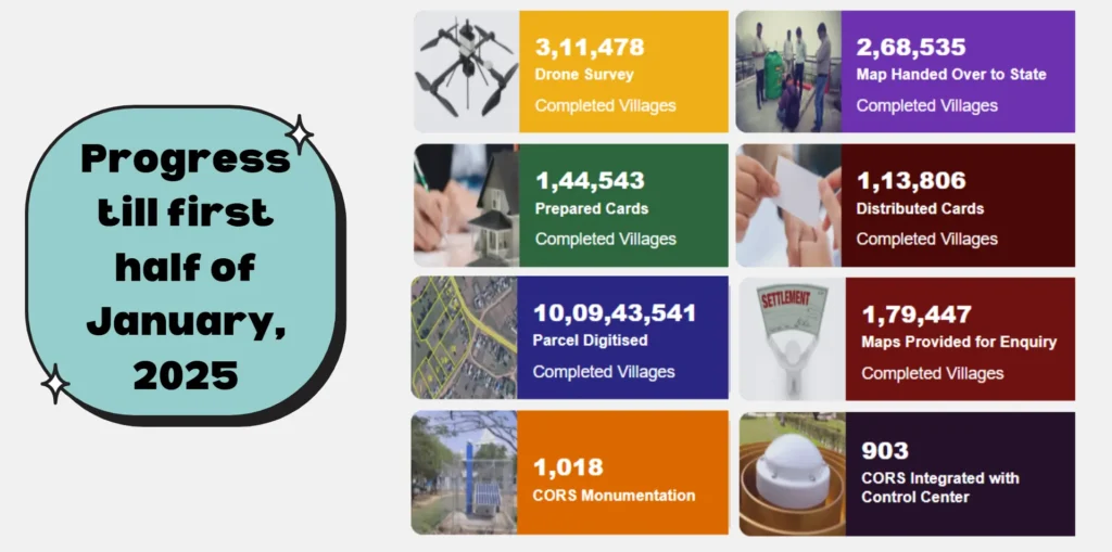
- Drone Surveys: Drone aerial photographs are high-definition images of village lands taken by drone. Such images are next analyzed in order to produce the correct map.
- Ground Verification: Survey teams are also used to do ground verification to double check some of the images that may be captured on the drones.
- Public Participation: People in villages take an active participation in the verification process. This way of specifying properties has the advantage of being acclaimed by all the participants and ensures transparent property cards.
- Issuance of Property Cards: After the preparation of the maps, property cards are also distributed to the concerned owners. These cards are also legal and are accepted by other financial institutions.
The SVAMITVA scheme has enjoyed the achievements since it was launched. Some pilot projects have been finalised and issue of property cards made to villages. It has tried to provide real benefits such as decreasing the sectional tensions, improving the credit availability, and increasing the economic operation. One of the main success stories can be extracted from the village of Garhi Harsaru in Haryana. Since the issue of these property cards, villagers have said that they have realized a dramatic reduction in cases of land disputes besides improved confidence in securing loans from commercial banks. This has resulted to increase in yield in farming and general improvement of the living standards.
Understanding the SVAMITVA Scheme
India’s SVAMITVA Scheme (Survey of Villages and Mapping with Improvised Technology in Village Areas) employs drone and geospatial technology to create digital records of rural land information. The SVAMITVA project achieves official property right recognition in rural villages to improve land ownership accessibility and governance effectiveness while establishing secure land registration systems for all area residents.
Objective and Vision
The program developed as a response to address the lack of established property documentation in rural districts. Villagers experienced restricted financial potential because traditional land ownership methods created on-going ownership disputes between people. Through the SVAMITVA program landowners obtain verified documents of ownership that enables them to obtain loans and pursue investment opportunities.
Technological Implementation
Drone-based mapping operates as the foundation of SVAMITVA to generate detailed accurate land records. Through SVAMITVA’s aerial surveys the system generates precise data linked to geographic properties which establishes valid ownership documentation.
Integration with Smart Governance
Gram Manchitra which serves as India’s rural development planning system enables the scheme to help build infrastructure that conserves the climate and supports sustainable village development. The system supports strategic resource management together with governance modifications which are supported by digital land records for long-term planning.
Ref: https://www.vajiraoinstitute.com/upsc-ias-current-affairs/india-showcases-svamitva-as-country-champion-at-the-on-going-world-bank-land.aspx
Source: Youtube
Also Read: